

Authors:
Leilani Battle, Ameya Patil, Trevor A. Branch, Zoe Rand

When we talk about fighting climate change, we rarely mention whales. In computing, we can understand low-power hardware and resource-efficient software, but where do whales fit in? As it turns out, large whales might be carbon-sequestration superstars [1]. They eat krill, zooplankton, and other organisms that feed on algae and phytoplankton, which remove carbon from our atmosphere (in some cases, better than trees can [2]). Large whales also cycle nutrients as they migrate, fertilizing the oceans and in turn boosting oceanic plant growth. Finally, whales can even hold carbon within their own bodies and safely deposit this carbon in the deep ocean when they die.
Despite how much large whales help protect our planet, we humans hunted them aggressively, even to near extinction, through commercial whaling. Thankfully, commercial whaling was banned in 1986 and many whale species have bounced back. That being said, some whale species such as Antarctic blue whales will still need decades more to fully recover. Others, such as North Atlantic right whales, face new human-caused threats from ship strikes and entanglement in fishing gear, and have declined in recent years.
We can use data science techniques to support conservation research on large whale populations. Specifically, researchers aim to measure where whales have been over time and how many whales were observed. These measurements can help us understand today's remaining populations and inform new strategies to protect them. Collecting the necessary data, however, is difficult. Whether tracking whales via sight, sound, or even remotely via satellite imagery, there is simply too much data to sift through to find a few whales within the vast reaches of the oceans.
As it turns out, there is a treasure trove of whale-specific data that covers more of the world's oceans than traditional whale-tracking efforts: the records kept by commercial whalers. Capitalism led us to hunt whales, but with data science we can adapt the resulting data for environmental good. For example, the International Whaling Commission (IWC) has collated more than 2 million records of individual whale catches over the last century and has made this database available upon request to researchers to support conservation efforts [3]. The IWC catch databases contain detailed information about commercial whaling expeditions such as the origin country, expedition route, total whales caught, where they were caught, and whale demographics such as sex, species, and so on.
However, the raw catch data fails to tell the whole story. For example, if whales are caught at two consecutive points along a whaling expedition route, then presumably the area between these points was also searched for whales. To infer search effort along the entire expedition route, we need the ability to interpolate between the raw data points. In other words, we need to analyze the data not only in terms of latitude and longitude but also in terms of the network graphs formed by the expeditions.
To address these challenges, we are developing a tool called WhaleVis [4] for analyzing historical whaling voyages. The WhaleVis project is a collaboration between computer science and whale researchers through the Computing for the Environment initiative (https://cs4env.uw.edu/) at the University of Washington. Because of this, we could design WhaleVis to facilitate the core analyses that whale researchers are interested in but struggle to perform on the IWC catch databases.
The WhaleVis interface is an interactive dashboard containing a mix of visualizations, such as a geographic map and timeline visualization to facilitate spatiotemporal analyses, and histograms and bar charts to visualize the distributions of various whale characteristics including sex, length, and species. Any visualization in the WhaleVis dashboard can be filtered along continuous axes (e.g., time, whale length) by using brushing and filtered by discrete axes (e.g., whale sex, whale species) by using point selections.
As a first step toward interpolating search effort, WhaleVis can draw lines between consecutive records from the same expedition route. This enables researchers to see where recorded expeditions have traveled and which regions have no information in the IWC catch data. In the future, we plan to expand this feature to further support route-based analyses; our ideas include pointwise selection of specific expeditions, aggregating similar routes to reduce visual clutter, and filtering for routes that pass through specific latitude-longitude regions.
To demonstrate the kinds of analyses that are possible with WhaleVis, we illustrate how specific species were sequentially targeted through commercial whaling in Figure 1. To minimize costs and maximize gains, commercial whalers targeted large whale species that were easy to catch when killed. For example, blue whales were targeted first in the Antarctic because they are the largest whale species with the highest return of oil for search effort expended. When blue whale populations were depleted, commercial whaling turned to fin whales, then sei whales, then minke whales. We see the time periods when each species was hunted (y), the size of the whales that were caught in terms of length (l), and the expedition routes taken across the globe to hunt them (e) at peak hunting periods for that species (third column) and when they were nearly driven to extinction (fourth column).
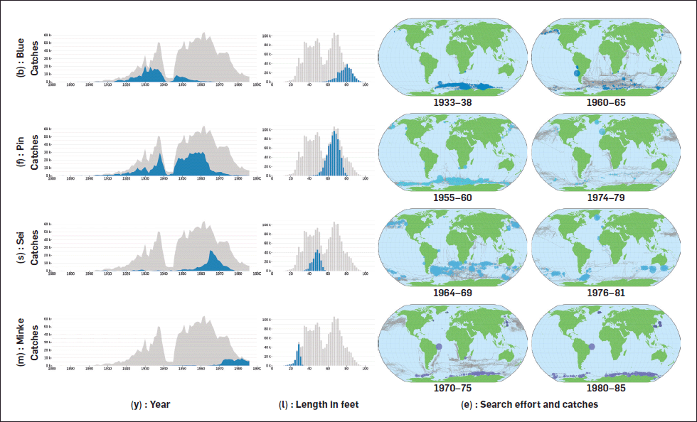 | Figure 1. A series of WhaleVis visualizations illustrating how specific whale species were targeted by commercial whalers over time. |
We are currently collecting feedback from whale researchers and the IWC community to refine the WhaleVis design. In the future, we hope to publicly release WhaleVis so that researchers all over the world can use it to gain new insights into where whale populations occur and how their numbers have changed over time. Furthermore, we see WhaleVis as one step toward integrating network-based and spatiotemporal analytics for conservation research, complementing existing tools such as EarthRanger (https://www.earthranger.com) and OBIS-SEAMAP (https://seamap.env.duke.edu).
References
1. Pearson, H.C. et al. Whales in the carbon cycle: Can recovery remove carbon dioxide? Trends in Ecology & Evolution 38, 3 (2023), 238–249; https://doi.org/10.1016/j.tree.2022.10.012
2. Buck-Wiese, H. et al. Fucoid brown algae inject fucoidan carbon into the ocean. Proc. of the National Academy of Sciences 120, 1 (2023), p.e2210561119; https://www.pnas.org/doi/10.1073/pnas.2210561119
3. Allison, C. IWC Individual Catch Database Version 7.1, 2020.
4. Patil, A., Rand, Z., Branch, T., and Battle, L. WhaleVis: Visualizing the history of commercial whaling, 2023 (under submission).
Authors
Leilani Battle is an assistant professor in the Allen School at the University of Washington. Her research focus is on developing interactive data-intensive systems that aid analysts in performing complex data exploration and analysis. She holds an M.S. and Ph.D. in computer science from MIT and a B.S. in computer engineering from UW. [email protected]
Ameya Patil is a Ph.D. student at the University of Washington. His research lies at the intersection of databases, data visualization, and human-computer interaction, with a focus on building data analysis systems for environmental science contexts. He earned his M.S. in computer science from the University of Maryland, College Park. [email protected]
Trevor A. Branch is a professor in the School of Aquatic and Fishery Sciences at the University of Washington. He uses computer models and data synthesis to assess the status of whale and fisheries populations and to improve fisheries management. He holds a Ph.D. in aquatic and fishery sciences from UW and a M.Sc. in conservation biology from the University of Cape Town. [email protected]
Zoe Rand is a Ph.D. student in the quantitative ecology and resource management program at the University of Washington. Her research involves quantitative analysis of historical whaling data to study the population dynamics of baleen whales. She holds an M.S. in marine mammal science from the University of St Andrews. [email protected]
Copyright held by authors
The Digital Library is published by the Association for Computing Machinery. Copyright © 2023 ACM, Inc.


Post Comment
No Comments Found